| The design
process is divided into the following phases. If you are
starting your design project, many of the forms are available in a
larger format suitable for printing directly from this site. |
|
 |
|
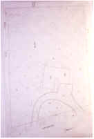
PLOT
PLAN OR ILC |
|
|
|
|
|
| SITE
SKETCH / PLOT PLAN |
|
|
|
|
|
|
A. |
YOUR LANDSCAPE
SOLUTIONS (YLS) meets with Owner(s) to discuss
and clarify the overall scope and budget range of
project: |
|
| Option
#1: |
in the
studio-office (a free 11/2 hour +/- meeting) |
|
| Option
#2: |
on project site
(at $150 per hour while on site with a one hour
minimum). If the Owner(s) decide to sign a Design
Services Contract with YLS with in 30 days of
first meeting, this hourly fee will be credited to the final
conceptual design fee amount. |
|
|
B. |
The Owner(s)
will provide to YLS either at the first meeting or
at least 7 days prior to the first meeting via fax
(720.283.3303, call before faxing) or via e-mail: tls@commonsenselandscaping.com |
|
|
|
1. |
A plot plan,
improvement location certificate (ILC), site sketch, or
topographic survey. |
|
|
2. |
House
construction plans if available, or a floor plan or sketch
indicating room arrangements and dimensions. |
|
|
|
|
|
|
D. |
YLS
reviews the project size, scope, complexity, and the
budget; then assigns a fee for the design services and
target dates for the completion of the design phases based
on the Fee Packages & Options for Landscape
Architecture Design Services currently offered. (YLS
does not quote fees or give estimates by phone, fax, or
e-mail) |
|
|
|
|
|
Design
Process |
|
SITE SURVEY AND
INVENTORY OF EXISTING CONDITIONS: |
|
|
|
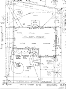
BASE
PLAN |
|
|
|
|
A. |
From the
Owner(s) plot plan, Improvement Location Certificate (ILC),
topographic survey, and/or house construction plans; YLS
will develop field sketches and notes to facilitate the
on-site survey and inventory by YLS, the survey
crew, or a licensed land surveyor.* |
|
|
B. |
YLS, the
survey crew, or a licensed land surveyor will survey, take
measurements, inventory, and record with photos and/or
video, all existing site conditions, elements, and
features.* |
|
|
C. |
YLS drafts, to
an appropriate scale (1/8" or 1/4" =
1'-0"), a Base Plan of the project site indicating
existing conditions, topography, elements, and features.* |
|
|
Note: |
* Owner(s) may
provide an accurate site survey and inventory (SSI)
with before photos and/or video, and an accurate Base Plan
to scale(1/8" or 1/4" = 1ft) with 1 foot
(preferred) or 2 foot vertical contour intervals on
reproducible vellum or a computer generated disc (based on
Autocadd.dwg Version 2000 or less), at no additional
charge. See YLS' SURVEY
& ANALYSIS REQUIREMENTS PACKET (SARP) for details. |
|
|
|
Design
Process |
|
ANALYSIS OF PROGRAM,
BUDGET, & EXISTING SITE CONDITIONS: |
| |
|
| YLS will
analyze: |
|
A.
|
The
Owner(s)' Program of Needs and Budget Range form and
Budget Development Worksheet to prioritize the needs,
wants, and desired requirements as well as budget range
guidelines to establish spending and phasing schedules
for consideration by YLS and the Owner(s) during the
Design phases. |
|
|
B. |
Existing on-
and off-site conditions, elements, and features that
reveal a need for attention during the conceptual
design development. |
|
|
C. |
Systematic
calculations and comparisons of existing site
conditions, elements, and features to determine
capabilities, capacities, orientations, and exposures;
to determine the good and bad features (the qualities and
liabilities) of the existing site. |
|
|
|
Design
Process |
|
DESIGN / SYNTHESIS: |
|
|
|
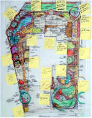
PRELIMINARY
CONCEPTUAL SOLUTION - A
(WITH COMMENTS) |
|
|
|
|
|
MASTER
LANDSCAPE PLAN
(MLP) |
|
|
|
|
|
AREA
LANDSCAPE PLAN
(ALP) |
|
|
|
|
A. |
PRELIMINARY
CONCEPTUAL DESIGN SOLUTIONS: |
|
|
|
1. |
YLS
develops two or more alternative studies, plans, and
estimates to fit the Owner(s) requirements to the
existing site and to indicate YLS's concept of
the best solution(s). |
|
|
2. |
YLS
will then meet with the Owner(s) to review and discuss
the alternative preliminary conceptual solution(s) to
the project so all parties will be thoroughly familiar
and in agreement with the preliminary solutions. |
|
|
3. |
The Owner(s)
will select and appove the final preliminary conceptual
design alternative and give directions to YLS on
the PRELIMINARY CONCEPTUAL DESIGN APPROVAL form as to how to
proceed with the completion of the FINAL CONCEPTUAL
DESIGN. |
|
|
|
B. |
FINAL
CONCEPTUAL DESIGN SOLUTIONS: |
|
|
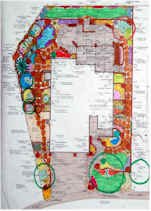
1. |
YLS
prepares a FINAL CONCEPTUAL DESIGN (MLP or ALP) from the
previously agreed to PRELIMINARY CONCEPTUAL DESIGN
indicating use areas and elements to be developed with
the physical shapes, sizes, materials, and colors
represented. |
|
|
2. |
YLS
prepares a FINAL COST ESTIMATE and PHASING SCHEDULE for
the completion of the project as agreed to by the
Owner(s) and whether to be completed by a landscape
contractor, the Owner(s) as a do-it-yourself project, or
as a combination of landscape contractor and Owner(s)
completed project; and/or coordinated by YLS. |
|
|
3. |
YLS will meet
with the Owner(s) to review and discuss the FINAL PLAN,
FINAL COST ESTIMATE, and PHASING SCHEDULE. |
|
|
4. |
With the
Owner(s) direction and approval, YLS will develop
professional services contracts for: |
|
|
|
|
|
|
|
|
|
|